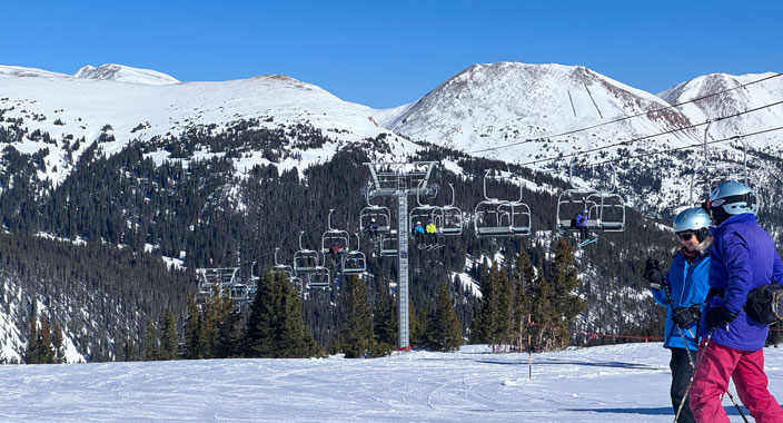
View along one of Colorado's Scenic Byways.

Colorado is Your Backyard Full of Adventure!

Colorado has 26 Scenic Byways; 13 are designated as America's Byways® by the US Secretary of Transportation, which gives Colorado more national designations than any other state. This is why we have more smiles per mile!

Depending on your starting point, one of these 6 byways might be your perfect Sunday Drive with a Picnic Lunch.

GUANELLA PASS SCENIC BYWAY connects Silver Plume and Georgetown to Grant in north central Colorado. The byway is 22 miles long and takes about 60 minutes to travel. THE ROUTE: Take I-70 west of Denver to Exit 228 in Georgetown; follow signs for Guanella Pass from the Gateway Visitors Center, or From South Denver take C-470 to US 285; head west to Grant, Colorado and turn onto CR 62. LOOKING FOR A PICNIC STOP, head to Geneva Creek Trailhead off CR 62 on the Grant side of the pass, there is a small picnic area with restrooms.

LOS CAMINOS ANTIGUOS SCENIC BYWAY is in the San Luis Valley connecting Alamosa to the top of Cumbres Pass though the towns of Mosca, Blanca, Fort Garland, San Luis, Antonito, Conejos and Mogote in south central Colorado. The byway is 129 miles long and takes about 3 hours to travel. THE ROUTE: From Alamosa take SH 17 north; in Mosca follow the signs to Great Sand Dunes National Park; at SH 150 head south to US 160 to Fort Garland. In Fort Garland take SH 159 to SH 142 till it connects with US 285 to Antonito, then head west onto SH 17 and over La Manga and Cumbres Passes. Extend your drive to Chama, New Mexico for a real treat. LOOKING FOR A PICNIC STOP, head to Great Sand Dunes National Park. This is a great place to stretch your legs, climb a sand dune and have a picnic lunch.

SANTA FE TRAIL SCENIC BYWAY features southeast Colorado: Bent's Old Fort National Historic Site, Colorado City, La Junta, John Martin Reservoir State Park, Lamar, Las Animas, Pueblo, Pueblo West, Rocky Ford, and Trinidad. The byway is 188 miles long and takes about 4 hours to travel. THE ROUTE: As you enter Colorado from New Mexico on I-25 you will summit Raton Pass at 7,834 feet elevation; in Trinidad take Exit 15 onto US 350 to La Junta. In La Junta you will head east onto US 50 through Lamar; your last stop in Colorado is Holly and then the Kansas Border. LOOKING FOR A PICNIC STOP, head to John Martin Reservoir State Park with picnic sites, swim beach, boat ramp and restrooms.

SILVER THREAD SCENIC AND HISTORIC BYWAY in southwest is near Gunnison, Blue Mesa Reservoir, Lake City, Creede, Wagon Wheel Gap and South Fork. The byway is 117 miles long and takes about 3 hours to travel. THE ROUTE: Start in South Fork (from US 160) or Gunnison (from US 50); the byway connects the two Highways via SH 149. LOOKING FOR A PICNIC STOP, head to North Clear Creek Falls Observation Site between Spring Creek Pass and Creede. There is a wheelchair accessible trail to the overlook, restroom, picnic tables, and ample paved parking.

SOUTH PLATTE RIVER TRAIL SCENIC BYWAY in northeast Colorado is near Julesburg, Haxtun, and Holyoke. The byway is 19 miles long and takes about 30 minutes to travel. THE ROUTE: Start in Julesburg, travel along US 385 to Ovid and back to Julesburg along US 138. LOOKING FOR A PICNIC STOP, head to DePoorter Lake along US 138 just south of Julesburg. This is a popular summer evening escape along the Overland Trail. Amenities: covered picnic area, restrooms, fishing, shades trees, and a wheelchair accessible pathway around the lake.

UNAWEEP/TABEGUACHE SCENIC BYWAY in northwest is near Grand Junction, Delta, Montrose, Naturita, and Nucla. The byway is 133 miles long and takes about 3 hours to travel. THE ROUTE: From I-70 in Grand Junction, take US 50 south. Turn onto SH 141 just outside of Whitewater; this is where the Byway starts. Follow SH 141 through Gateway, Uravan, Vancorum; at Naturita take SH 145 to Placerville where the route ends. LOOKING FOR A PICNIC STOP, head to West Creek Picnic Area between Driggs Mansion and Gateway Colorado Auto Museum.

PRO TIP:: Remember to fill up your gas tank and bring your picnic lunch. Cell phone coverage is available in the majority of Colorado towns, but once you're out on a back-road or mountain summit, you'll most likely go off the grid. Before you head out, be sure to let others know where you are going and take plenty of photos to share with your friends and family once service returns.

Colorado Vacation Planning - Cabins, Motels, Campgrounds, Vacation Homes, RV Parks

Our Colorado Partners

Clear Creek Rafting Company Thumbnail
Clear Creek Rafting Co.
Argo Historic Gold Mill and Tunnel Logo
Argo Mill & Tunnel
Colorado Parks and Wildlife Logo
Colorado Parks & Wildlife

Featured Colorado Maps

Explore Colorado's Towns by Region:
Colorado Regional Map
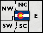
View Colorado Regions Map

Click Here For Current Colorado Road Conditions
Colorado Department of Transportation

Downloads - Great Vacation Resources on Colorado

horizontal rule
Follow Us
Follow us on Facebook Button Follow us on Pinterest Button Follow us on Instagram Button

Places to Stay, Rentals & Amenities
Cabins & Cottages | Motels & Hotels | Lodging & Lodges | Vacation Homes | Condos, Suites & Townhomes | Bed & Breakfast | Tent Camping | RV Parks & Campgrounds | RV Sales, Service & Rentals | Romance Packages | Family Friendly | Pets Welcome | By Water | Swimming Pools | Guest Horses | Groups, Reunions & Retreats | Weddings & Elopements | Winter Lodging

Fun Things to Do
Calendars of Events | National Parks, Monuments & Historic Sites | Scenic Byways & Drives | Fishing & Fly Fishing | Hot Springs | Horse Riding | ATV/UTVing | Jeeping & 4WD | Whitewater Rafting & Kayaking | Attractions | Golfing | Restaurants & Dining | More Fun Stuff | Hunting & Land Leases | Snowmobiling | Downhill Skiing & Snowboarding | Snowshoeing | Cross-Country Skiing

A-Z Towns & Areas | Colorado Maps | About Us

Established 1980 | ©Copyright by The Colorado Directory, Inc. This is a directory only; it is not and does not contain a recommendation, warranty, guaranty, inducement or endorsement of any kind. Representations herein were supplied by the individual businesses. The publisher, The Colorado Directory, Inc., does not assume any responsibility for truth, falsity or completeness of any representation made herein or any errors, changes, services rendered, or changes made in the use of this directory. This information was compiled as accurately as possible. Prices and services are frequently subject to change. Errors called to the publisher's attention will be corrected in the future. All rights reserved. No part of this publication may be reproduced, stored or transmitted in any form or by any means, without permission in writing from the publisher.